What Are The Uses Of Drone Surveying?
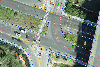
Drone surveying is the latest technology used for land mapping. It is advantageous in many ways and it has benefits for everyone from city planners to security managers. Everyone needs a bird’s eye view of the development work because it is all-inclusive. You can see a vast area in one frame without scrolling the image up and down. Let’s understand the advantages of using drones for mapping 1. City planning City planning becomes easy when you have complete data on the land where a city is planned. If you can see the piece of land from above, you can view everything from green areas to dry areas. You can identify natural resources and plan the development in such a way that it causes minimum damage to the environment. 2. Construction management Aerial scanning has made it easier to manage construction work. For example, you can see how the construction material is scattered on the site. You can even monitor the quantity of construction material consumed and wasted. Also, you can...